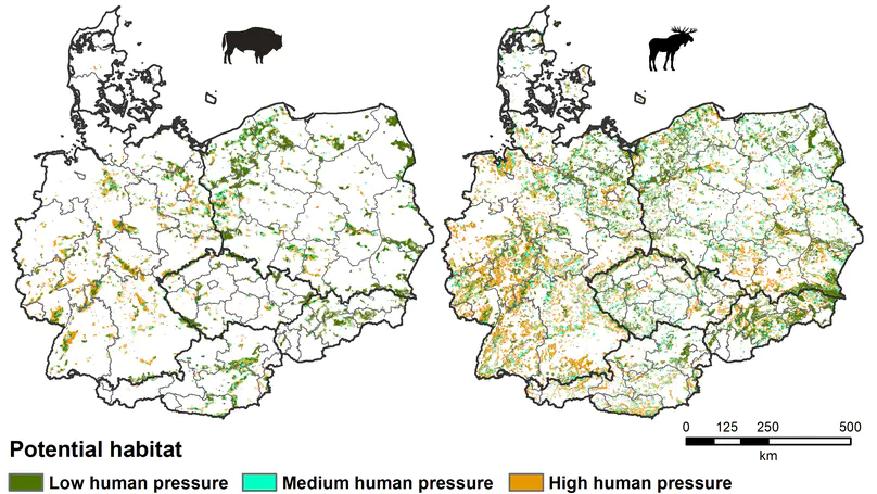
Conservation planning traditionally has focused on identifying priority areas for threatened species. We developed an approach to additionally consider those species – threatened or not – that are important for local communities who use them. In this way, planning for protected areas that benefit both, conservation and sustainable development goals becomes possible. For the Chaco, this shows that large areas exists where such co-benefits could be leveraged.

By coupling species distribution models with different dispersal scenarios, we highlight that the ability of large carnivores to colonize and ultimately coexist with people in shared landscapes is likely most constrained by human pressure and their impact on dispersal behavior and not by available habitat.

By combining species distribution modelling with a spatial prioritization framework, we aimed to identify where grazing right buyouts should take place to reduce cheetah killing by herders and their dogs. Our results provide a novel approach to minimize the mortality risk for cheetahs in Iran.

Here, we used a combination of remote-sensing and field-measured productivity indicators to demonstrate that in temperate ecosystems brown bears attack more beehives in years of beechnut crop failure. Our study provides empirical evidence on how bottom-up effects of resource pulses, such as masting, shape the interactions between wildlife and humans. Furthermore, we demonstrate that combining weather cues and remote-sensing indicators of vegetation growth and phenology can explain and predict year-to-year variation in beechnut production linked to wildlife damage, which can help to improve conflict management and proactively reduce conflicts.

We gather all available information on tropical deforestation and its drivers and synthesize it to provide clarity on how agriculture drives deforestation. Up to 99% of all tropical deforestation is driven by agriculture, but only 45-60% of deforested areas actually were used for agricultural production.

We propose a new way of using satellite imagery to move from the reconstruction of land-cover/use change towards the identification of frontier processes – a major milestone towards better understanding how agricultural frontiers expand in tropical dry forests.

Wars are unfortunately very frequent across the globe, but how they affect agricultural land varies. We showed that in the Caucasus up to one third of agricultural abandonment was related to the wars after the collapse of the Soviet Union. But not only do wars with a high conflict intensity affect agricultural land use, but also wars with a relatively low conflict intensity like the one in Abkhazia. We found that the wide-ranging agricultural abandonment in Abkhazia was most likely related to indirect drivers like post-war policies.

Ranger patrols are the most common conservation measures against poaching in protected areas. We extracted, digitized and analyzed ranger-collected data from logbooks to predict poaching prevalence, its determinants and to devise future patrolling strategies.

We develop an approach to map spatial and temporal patterns of deforestation frontiers and apply it to the world’s tropical dry woodlands. We find across regions, areas under drastic loss, termed rampant frontiers, and that many frontiers are just starting to unfold.